 Devon, famously, has more miles of road than any other county in England. It's perhaps not surprising that the County Council never got round to Tarmacking all of them: there are still hundreds of miles of roads with no asphalt surface that are still legally open to all traffic.
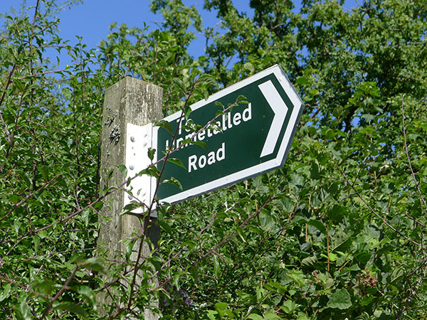
Whilst many councils have reclassified unsurfaced roads as Byways Open To All Traffic (BOATs), Devon has not, and still refer to their unsurfaced roads as 'unmetalled roads', marked on the ground with green-backed fingerposts and black 'County Road' arrows. These roads are marked by green dots on Ordnance Survey maps. They are informally known as 'Green Lanes' thanks to their often overgrown nature!
In theory, anything can use these roads at up to 60mph: only a fool would drive an ordinary car down one. Most of the green lanes have not been repaired for years, and have ruts that may be several feet deep. Mountain bikers, motorcyclists, farm machinery and four-wheel-drive vehicles may sometimes be found on the lanes, but usually they are best suited for walkers.
There are five Green Lanes in the parish:
There are several nearby, including:
 You can read more about Green Lanes in the South Hams in a book by local author Valerie Belsey. Her book "Exploring Green Lanes in the South Hams" was published in 2003 by Green Books (ISBN 1-903998-24-7) and an updated edition has been republished by the Eastgate Bookshop in Totnes in 2022 (ISBN 9-781739-694500), priced £7.99.

Lupridge Lane runs from Lupridge to Coarsewell, crossing the border of the parish into Ugborough. It is a typical stony green lane that plunges steeply into the valley, hinting at why more motor-car friendly roads were chosen for Tarmacking.

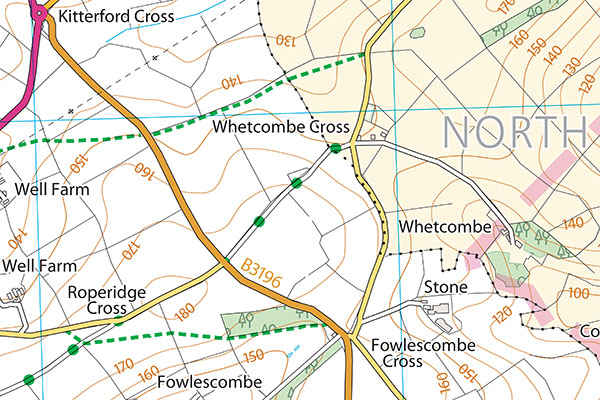
A short green lane runs from Whetcombe Cross to the B3196 in the direction of Roperidge cross, where a Tarmacked road links with Spriddlescombe Lane towards Ugborough.
An almost indistinguishable lane runs through open fields from Charford Cross to Webland Lane. Although both ends can be identified as roads, most of the road has had its hedges removed and been levelled with the field surfaces. Nonetheless, it is still officially a public road. It has recently been signed as 'unsuitable for motor vehicles': it most certainly is.


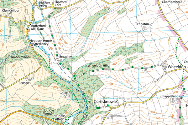
Just across the Diptford parish boundary, a green lane links Diptford Cott to Curtisknowle via Broadley, and is a useful link to the Miller's Path bridlepath to Gara Bridge, though it can be flooded in places. Combining this lane with the Hothole Cottages to Stretchney footpath (North Huish Footpath No. 6) makes a pleasant circular walk, particularly when the spring flowers are in bloom.
Stony Track is the exception to the rule, because, despite its name, it was Tarmacked and maintained as a surfaced road until the A38 was built, at which point the road to Stidston was improved instead. It crosses under the A38 between New Cross and South Brent, and provides an alternative route between Avonwick and our neighbouring village. It crosses the former railway line on a bridge that is now level with the ground, thanks to earth from the A38 construction being used to fill in the cutting.
